The Whole Enchilada Loop
Name: The Whole Enchilada Loop
Start: Left turn from Fourth E St onto S Mill Creek Dr
Finish: Tunnel at the end of Porcupine Rim trail
GPX: Strava Segment
Distance: 55.27 miles
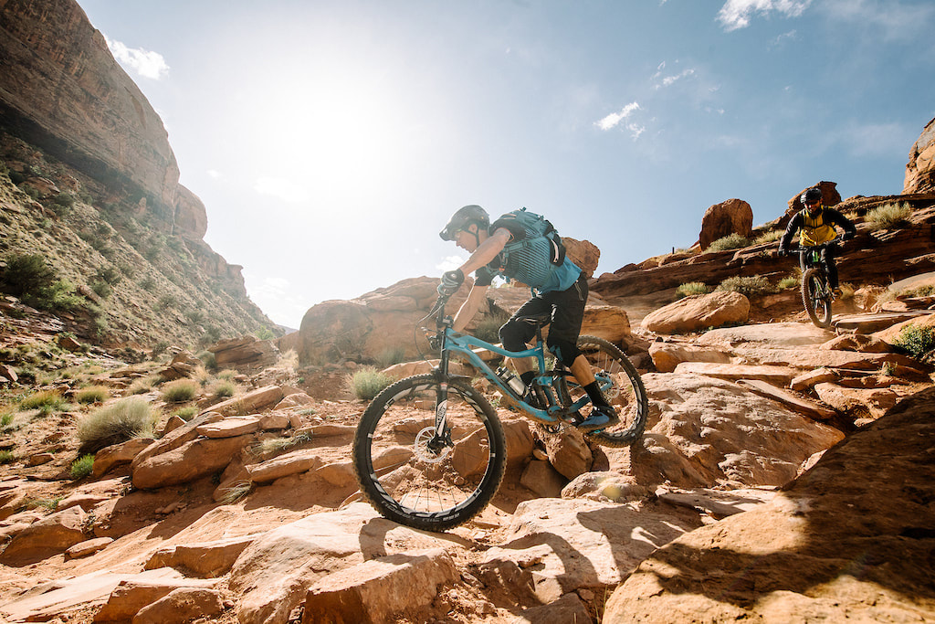
Description: The Whole Enchilada Loop combines the trail, The Whole Enchilada which runs from the La Sal Mountains into Moab and the road leading to the start of the ride. The trail is possibly one of the best mountain bike rides in the world. It features a variety of surfaces and trail styles, all the while paralleling cliff sides and gorgeous views of the Colorado River. It is not always possible to do the entire ride depending on weather and snow conditions. Tourists typically take a shuttle most of the way up, and climb only a few hundred feet to Burro Pass. This route starts on pavement just outside of town, at the left turn from Fourth E St. onto S Mill Creek Dr. and climbs all the way to Burro Pass, then descends to the tunnel at the end of the Porcupine Rim trail. By the end of the ride, elevation gain totals typically exceed 8,000 ft.
Unsupported:
Men: Keegan Pelton, 9/29/23, 4:51:56
Women: Hannah Otto, 10/11/22, 5:50:38
Supported:
Men:
Women:
Team:
Para:
Name: The Whole Enchilada Loop
Start: Left turn from Fourth E St onto S Mill Creek Dr
Finish: Tunnel at the end of Porcupine Rim trail
GPX: Strava Segment
Distance: 55.27 miles
Description: The Whole Enchilada Loop combines the trail, The Whole Enchilada which runs from the La Sal Mountains into Moab and the road leading to the start of the ride. The trail is possibly one of the best mountain bike rides in the world. It features a variety of surfaces and trail styles, all the while paralleling cliff sides and gorgeous views of the Colorado River. It is not always possible to do the entire ride depending on weather and snow conditions. Tourists typically take a shuttle most of the way up, and climb only a few hundred feet to Burro Pass. This route starts on pavement just outside of town, at the left turn from Fourth E St. onto S Mill Creek Dr. and climbs all the way to Burro Pass, then descends to the tunnel at the end of the Porcupine Rim trail. By the end of the ride, elevation gain totals typically exceed 8,000 ft.
Unsupported:
Men: Keegan Pelton, 9/29/23, 4:51:56
Women: Hannah Otto, 10/11/22, 5:50:38
Supported:
Men:
Women:
Team:
Para:
Notes from the trail
Notes from Keegan Pelton's successful attempt:
As for the ride itself, it was really a mind melter. Starting at 4000 feet and going up to 11,000 feet, keeping the same power becomes harder and harder. The first 15 miles are a shallow grade, and I had to uncomfortably force myself into an aero position while still putting out the requisite power. I managed to keep pace throughout the climb, maintaining 240 watts even with the increasing elevation. By the last bit up to Burro Pass, my inner thighs had started to cramp, a reflection of doing zone 3 for 3 hours straight. I had to hike a bike once on a super steep and loose section, but other than that I cleaned all of the main climb. The descent started well, but there were about 8 shuttle loads of people who had passed me on the climb that I had to get through which definitely slowed me down a bit. Once I got to the first doubletrack downhill, I had passed most people and had a clear trail ahead. The trail becomes chunkier and requires less and less pedaling the further down you go, so by the end my breath was normal and my legs were recovered, but my back, hands, arms, and mental state were so shattered that I was just trying to survive the downhill.